AFLUX 2019
Arctic Amplification: Fluxes in the Cloudy Atmospheric Boundary Layer
March 20 to April 15 2019, Longyearbyen/Svalbard
Important (preliminary) dates concerning AFLUX:
AFLUX is a joint project of different German universities and research institutes and of one French university (listed under Institutions). It is embedded in the Transregional Collaborative Research Centre TR 172 (ArctiC Amplification: Climate Relevant Atmospheric and SurfaCe Processes, and Feedback Mechanisms (AC)³). The general goal of AFLUX (Joint Aircraft campaign observing FLUXes of energy and momentum in the cloudy boundary layer over polar sea ice and ocean) is to obtain a comprehensive data set of atmospheric parameters in the polar cloud-covered and cloud-free atmospheric boundary layer (ABL) over sea ice. Flights will be arranged in a way that the data can serve to improve our understanding of boundary layer processes dependent on the dominating impact factors such as clouds, sea ice cover, surface temperature and wind. The combined analysis of the measurement data and of suitable modeling results will be used to estimate the role of Arctic clouds and of surface heterogeneities for the amplified climate change in polar regions. Special emphasis is on the comparison of results during this winter/early spring campaign with the ACLOUD – (AC)³ campaign carried out during late spring/early summer in the same region in 2017 (Wendisch et al., 2018).
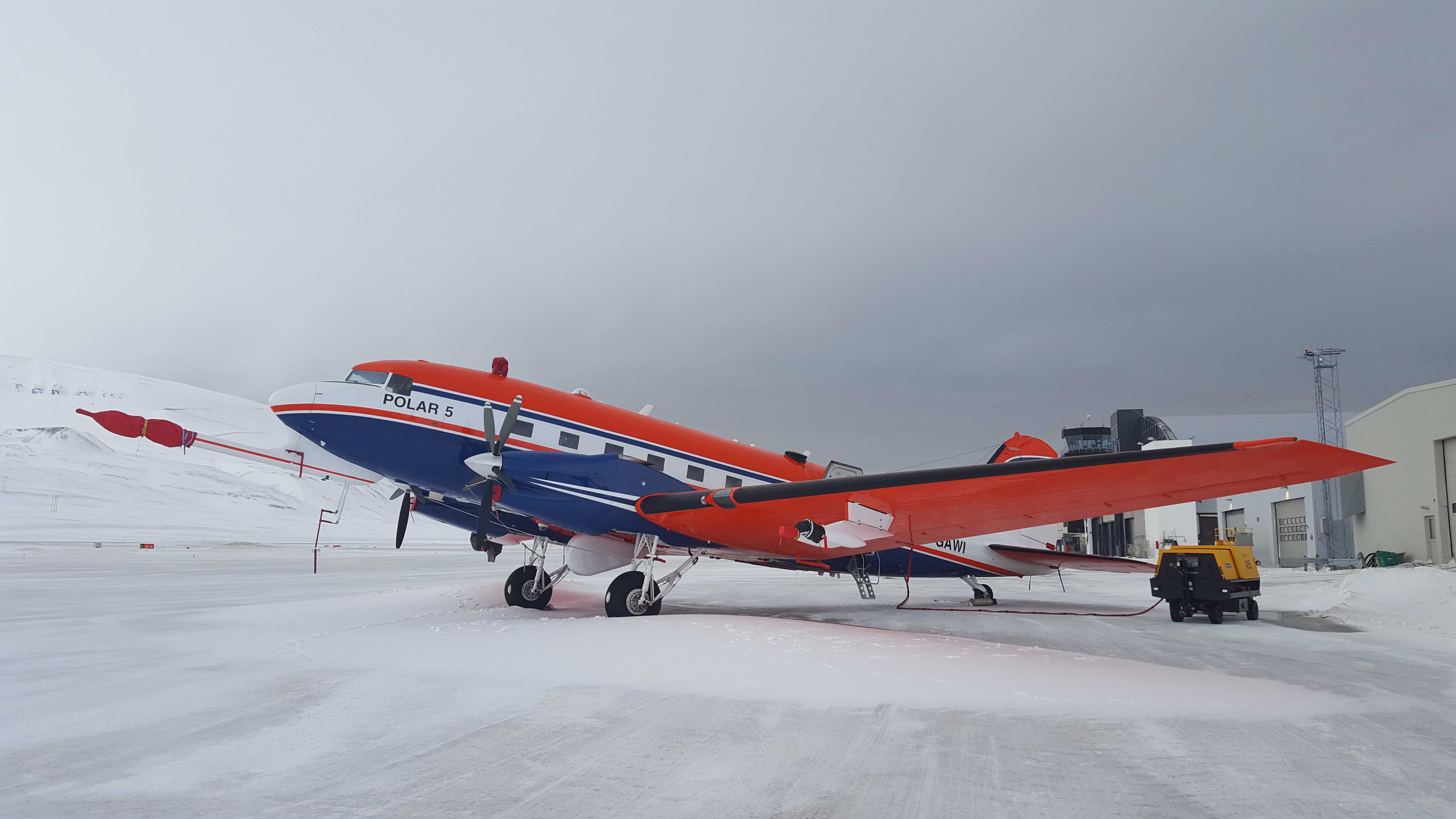
AFLUX will employ one research aircraft, Polar 5, operated by the Alfred Wegener Institute, Germany. To reach the goals described above, the research flights aim to measure turbulent and radiative fluxes of energy and depending on the properties of low-level clouds and aerosol particles, as well as on trace gas concentration. To that aim both in situ measurement techniques and remote sensing instruments will be applied.
80 flight hours are planned within about 4 weeks (15 March – 16 April 2019). Polar 5 will approach the ice-pack mainly in altitudes of 3,000 m (10,000 ft). Then, flights will be performed in different levels above and below clouds if visibility conditions are sufficient. During descend clouds will be probed under suitable conditions with only very weak icing. If conditions allow, also short horizontal flight legs are planned in clouds. Such conditions might be found in shallow stratocumulus over sea ice where humidity is lower than at the sea ice edge. The lowest possible flight level is at 60 m (200 ft) above ground, which is needed to characterize turbulent fluxes in the lower part of the atmospheric boundary layer below clouds as well as to measure the surface temperature and the surface reflectivity.
The base for the aircraft operation will be Longyearbyen, (Svalbard Lufthavn, LYR) and flights will be performed in the region 75N-85N and 30W-28E. We strive to minimize the environmental impact of our research activities. E.g., to our best knowledge, the environmental impact of our activities will be limited to (a) aircraft noise, (b) aircraft exhaust fumes, and (c) 40 meteorological probes released from the aircraft.
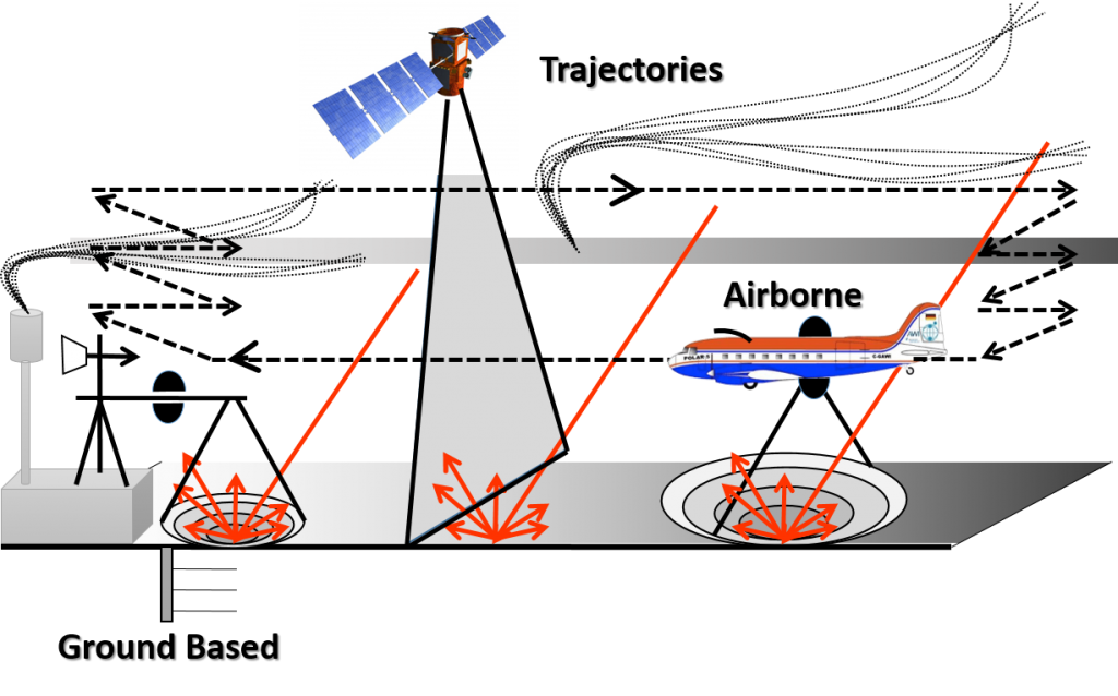
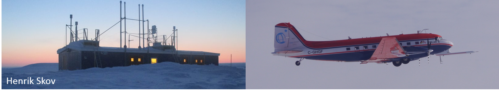
The airborne observations will be closely coordinated with surface-based observations at the AWIPEV station (Ny-Ålesund).
A third aircraft campaign (AFLUX), based at the Station Nord (Greenland), with one of the two AWI aircrafts is planned for 2019. The objectives and instrumentation are similar to ACLOUD, although somewhat reduced because probably only one aircraft will be available
Strategy
The main motivation for this project is the pressing need to improve the understanding of the physical processes in Arctic clouds, their interaction with the sea ice cover, and their contribution to the current changes in the polar environment. Especially the interaction with the ice surface is not well represented in models, which is due to the small scales involved.
Current studies have furthermore shown that depending on their properties clouds may act as a warming or cooling factor in the arctic environment. However, parameterizations and general assumptions about clouds lead to uncertainties of the representation of these cloud effects in regional and global weather prediction and climate models. Airborne observations are a valuable method to verify and to improve those assumptions and to reduce the model uncertainties. However, airborne measurements are limited in time. Therefore, one aim of AFLUX is also to combine the airborne observations with ground-based long term observations at Ny-Ålesund.
Objectives
Our research target will be cloud fields (in particular, mixed-phase, ice and liquid water stratiform clouds in the boundary layer), which can appear anywhere within the range of our aircraft. As a reference, also flights in clear-sky condition over the same area are envisioned. The maximum distance from Longyearbyen is 750 km, or 400 nautical miles. The exact flight tracks will depend on the current weather situation, in particular on the occurrence of cloud fields, the sea ice cover, and wind direction since the ideal flight pattern will be performed parallel to the mean wind.
Location
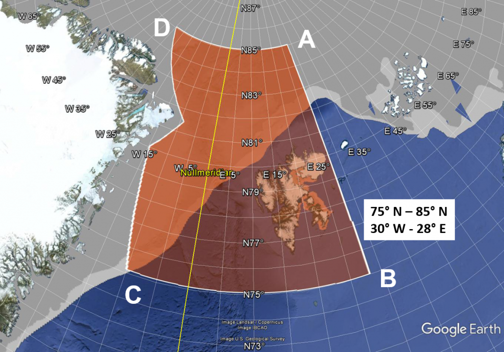
The Polar 5 aircraft will perform multiple science flights from Longyearbyen airport, Svalbard (Svalbard Lufthavn, LYR). Permission is requested to operate the aircraft in a possible sector defined by four points (A, B, C, D) with coordinates
A 85° N / 28° E
B 75° N / 28° E
C 75° N / 10° W
D 85° N / 30° W.
Individual flights will be located within this sector but in a smaller sub-region depending on the aircraft’s range (payload), on the sea ice conditions and on weather. In the last decade sea ice cover was highly variable in the highlighted region shown in Figure 1. The variability concerns especially the position of the pack ice edge North and West of Svalbard and the sea ice cover on Storfjorden (SouthEast of Spitzbergen).
During each flight we will try to reach the ice edge with a reasonable reserve for flight patterns also beyond the sea ice edge over the sea ice covered part.
The airborne observations will be closely coordinated with surface-based observations at the AWIPEV station (Ny-Ålesund).
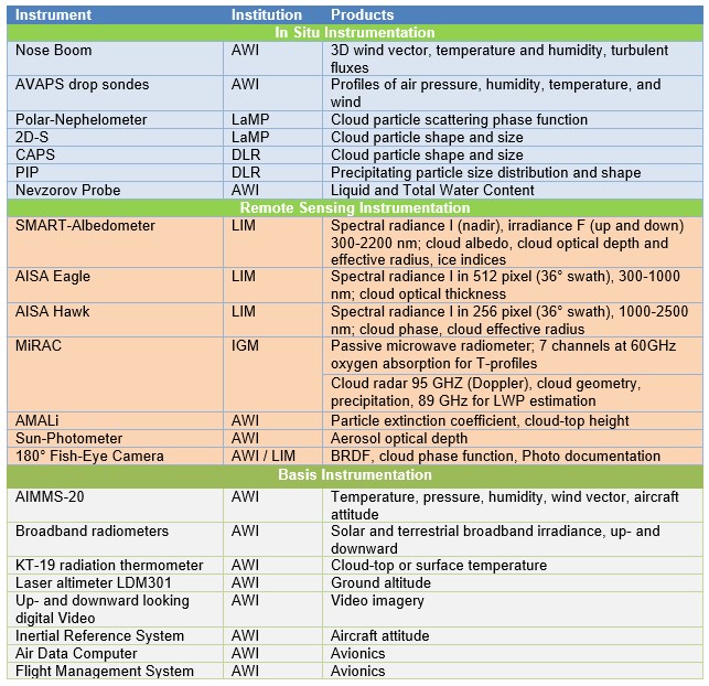
Instrumentation of Polar 5 for turbulent and radiative flux measurements and in situ and remote sensing clouds observations.
We will perform airborne measurements with the Polar 5 owned by Alfred Wegener Institute Helmholtz Centre for Polar und Marine Research, Germany, and operated by Kenn Borek Air, Canada. In general, the aircraft will not fly at low altitudes until it is safely away from the coast. No landing of the aircraft outside Longyearbyen will take place during each mission. The aircraft will avoid bird/wildlife sanctuaries. The crew on board the aircraft will look for marine mammals on the sea ice, and if encountered during low altitude flight, the aircraft will change course to avoid them.
The target of the research flights is the sea ice covered area. Flights will be performed there in cloud covered, but also in cloud free conditions. The latter need to be investigated in order to compare the turbulent and radiative fluxes with those measured in the cloudy areas. Part of the flight strategy will include profiling the atmosphere, again in both cloud covered and cloud free regions.
To characterize the cloudy boundary layer, we aim to probe low-level stratiform clouds over sea ice and open water (typically cloud altitude between 1000–6000 ft / 300–2000 m). The scientific objective is to observe those clouds from above and to probe the atmosphere below and inside the clouds. To this purpose, two kinds of flight strategies are required, one for “remote sensing” (passive solar, microwave, active radar, lidar) and one for “in-situ probing” of the turbulent fluxes and individual cloud particles (concentration, size, phase, shape). These different strategies can be realized by Polar 5 either by combining flight sections for remote sensing with in situ sections during individual flights or by realizing only one strategy, e.g. remote sensing, during some flights. In situ and remote sensing flight section should be collocated on the same flight tracks (following the same track but in different heights). This is essential for our research strategy during most of the flights to reach our research goals.
Possible flight patterns are explained below in more detail. There, we distinguish between the ferry flights to/from the locations of main measurements and the patterns at these locations/regions
Ferry 1: Polar 5 will perform remote-sensing observations (see Figure 3) typically at a constant altitude above the cloud top (typically near the maximum aircraft altitude; 10,000 ft / 3,000 m). These legs are straight lines and are sometimes coordinated with satellite overpasses. Some drop sondes will be launched at 10,000 ft (3 km) to determine the vertical structure of the atmosphere but only over uninhabited areas.
Ferry 2: If the endurance allows, ferries back home can be used to repeatedly probe the boundary layer by consecutive saw tooth pattern (climbing-descending, see Pattern B) in low altitude.
Pattern A:
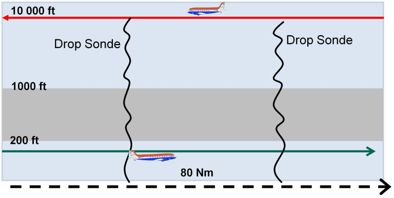
The area of intense observation (AIO) will be approximately over sea ice. Polar 5 will arrive at the pack ice edge and will then go down with a fast descend rate of 1000 ft/ min to reach 200 ft above the surface. A horizontal distance of 80 Nm is flown parallel to the mean wind at this height. A fast ascend will follow to 10.000 ft. At this level the aircraft flies back while releasing a series of drop sondes. This basic pattern can be varied with respect to heights and lengths of the tracks.
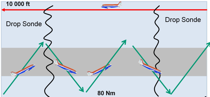
Pattern B:
This patterns consist basically of a saw tooth pattern over the ice and cloud covered region. Ascend and descend rates as well as the number of saw teeth can be varied. But a typical climbing rate should be 200 ft /min. This allows to measure turbulent and radiative fluxes as well as cloud particles sufficiently accurate.
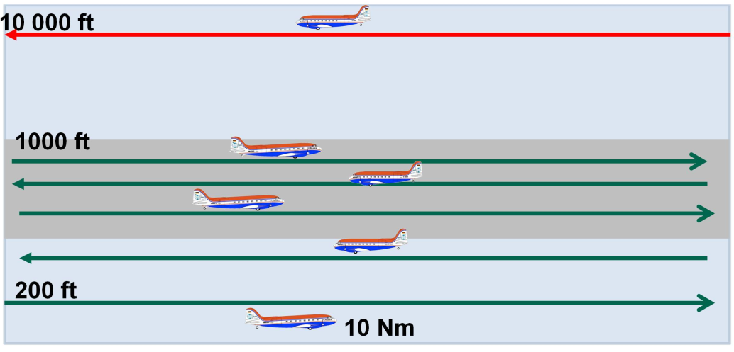
Pattern C:
This pattern serves as the basic pattern to measure vertical profiles of fluxes and particles. A large number of horizontal flight legs (e.g., 10) should be flown to achieve a high vertical resolution. If flight time allows, the pattern should be repeated at different positions preferably on the downwind and upwind side of leads or in a region with a section characterized by very homogeneous sea ice cover. Lengths of legs and heights must be varied according to the cloud and sea ice conditions. Such a pattern is also helpful when no clouds are present.
Pattern D (Alternative – Satellite Overpass):
Coordination with satellite observations. This pattern will be flown on a straight leg along the satellite overpass. Polar 5 will perform mostly remote sensing at 10 000 ft altitude with a few sections in the cloud if icing conditions will allow this. The total length of the leg may range about 60 nm, about 15 min before and 15 min after the satellite overpass.
Participating Institutes